
An important cultural heritage in the walled city historical texture of Nicosia: “Victoria street ”
Un importante patrimonio cultural en la textura histórica de la ciudad amurallada de Nicosia: “Calle Victoria”

Abstract
Victoria Street is the most important arterial street of Arabahmet Neighborhood, an important part of the walled city of Nicosia, the capital of Cyprus, which houses the historical city texture. A cultural mosaic embodied in its architectural heritage, the formation of the street texture dates back to the Byzantine period of Cyprus. Beginning in the Lusignan period with the Armenian Church still standing today, the historical street texture did not show any development during the Venetian period. The formation of texture of Victoria Street continued in the Ottoman period, and a symbol of the street and the city, ArabahmetPaşa Mosque and XIX. Century Traditional Turkish Houses have taken place in its texture. The historical street texture saw its most important formation and development process during the British period. Besides many buildings with shops on the ground floor and houses on the upper floors built during this period, concrete buildings of shops and houses, three-floor apartments built towards the end of this period contributed to the shaping of the street. The Catholic Church within the present day historical texture of the street was also built during the British period, and forms the border of the street at its south end. During the Republic of Cyprus period, which began in 1960, concrete shops and houses were built in place of buildings tumbling down, and the development of the street texture continued. However, because of the political strife between the communities in Cyprus, the demographical profile of the street changed and this historical texture was neglected. Later, some of the Traditional Turkish House style buildings were renovated with funding from the United Nations and became functional. The aim of this study is to analyze the formation and development of Victoria Street, which is an important cultural heritage within the historical texture of the walled city of Nicosia, through various historical periods, and to establish the physical and social status and its important place in the city beginning with the first construction of the street texture to the present. Information was gathered from written and visual resources for the study using a qualitative research method. The street texture was examined with a field study and photographed.
Keywords
Cultural Heritage, Cyprus, Historical Texture,Nicosia, Walled City.
Resumen
Victoria Street es la calle arterial más importante del barrio de Arabahmet, una parte importante de la ciudad amurallada de Nicosia, la capital de Chipre, que alberga la textura histórica de la ciudad. Un mosaico cultural encarnado en su patrimonio arquitectónico, la formación de la textura de la calle se remonta al período bizantino de Chipre. Comenzando en el período de Lusignan con la Iglesia armenia todavía en pie hoy, la textura histórica de la calle no mostró ningún desarrollo durante el período veneciano. La formación de la textura de la calle Victoria continuó en el período otomano, y un símbolo de la calle y la ciudad, ArabahmetPaşa Mosque y XIX. Las casas tradicionales turcas del siglo han tenido lugar en su textura. La textura histórica de la calle vio su proceso de formación y desarrollo más importante durante el período británico. Además de muchos edificios con tiendas en la planta baja y casas en los pisos superiores construidas durante este período, edificios de hormigón de tiendas y casas, apartamentos de tres pisos construidos hacia el final de este período contribuyeron a la configuración de la calle. La Iglesia Católica dentro de la actual textura histórica de la calle también se construyó durante el período británico, y forma el borde de la calle en su extremo sur. Durante el período de la República de Chipre, que comenzó en 1960, se construyeron tiendas y casas de concreto en lugar de edificios que se derrumbaban, y el desarrollo de la textura de la calle continuó. Sin embargo, debido a la lucha política entre las comunidades en Chipre, el perfil demográfico de la calle cambió y esta textura histórica fue descuidada. Más tarde, algunos de los edificios de estilo tradicional de la casa turca fueron renovados con fondos de las Naciones Unidas y se hicieron funcionales. El objetivo de este estudio es analizar la formación y el desarrollo de Victoria Street, que es un importante patrimonio cultural dentro de la textura histórica de la ciudad amurallada de Nicosia, a través de varios períodos históricos, y establecer el estado físico y social y su lugar importante en la ciudad comenzando con la primera construcción de la textura de la calle hasta el presente. Se recopiló información de recursos escritos y visuales para el estudio utilizando un método de investigación cualitativa. La textura de la calle se examinó con un estudio de campo y se fotografió.
Palabras clave
Patrimonio cultural, Chipre, Textura histórica, Nicosia, Ciudad amurallada.
Introduction
As people moved from nomadic life to permanent settlement, the settlement areas were created with transportation axes enabling relationship between buildings of different functions and public spaces; thus the concept of street came into being. With their creation and development through the historical process, streets added value to common life as historical texture elements reflecting the accumulation of culture where they take place.
In the capital city of Cyprus, Nicosia, there are street textures, which began in the Lusignan period (1191-1489) and developed with the architectural works belonging to various historical periods that still exist as cultural mosaics each. One of the neighborhoods of Nicosia where such streets of protected historical quality are concentrated, is the Arabahmet Neighborhood, close to Sarayönü Square in the center of walled city of Nicosia that has housed administrative buildings throughout the history of the city.
This study aims to look into Şehit Salahi Şevket Street, still known as “Victoria Street”, with its sustainable history, which is the main artery of Arabahmet Neighborhood, and symbolizes the historical periods of Cyprus with the architectural works of its texture and its importance during the British period. The formation and development of Victoria Street is researched from the first building there until the present day, with buildings of various cultures, and it is aimed to establish its important place in the city with the changes throughout the process of its development. This research started with a literature review of the history of Nicosia and the buildings in Arabahmet Neighborhood and Victoria Street, and it was realized with a qualitative study method supported by on-site examination, observation, and photography. The fact that there are no detailed studies carried out previously on the formation and development of the historical texture of Victoria Street, makes this research important, and it is hoped that it will become a resource for future studies on the texture of historical streets of Nicosia.
Methodology
This study is a detailed analysis of the historical formation and development of Victoria Street, which is an important cultural heritage of Arabahmet Neighborhood, one of the historical neighborhoods of the city center of walled city of capital Nicosia, where the historical city texture takes place.
Qualitative research method was used in this study. A literature review of written and visual resources were examined for historical information and past visuals related to the topic. In addition, on-site observations, examinations and interviews were carried out through field studies in the street, establishing findings about the historical texture. The present day appearance of architectural words were also documented by photographing them.
At first, information about the history of Nicosia was conveyed, using resources on the history of Nicosia, summarizing it from its foundation to the present day, displaying its development through the various historical periods of the history of Cyprus. After that, the importance of Arabahmet neighborhood (in which Victoria Street takes place) within the historical texture of the city was defined both in history, and its present day importance as a special protection area was presented using visuals of the city plan, showing the walled city and the place of the neighborhood.
Research of the formation and development of Victoria Street was initiated by describing the place of the street in the city, and it was supported by visuals showing the street and its proximity on the city plan, and the present state of the historical texture of the street. The historical texture of Victoria street, beginning with the construction of the first building in its formation, and all the architectural works and the historical periods of Cyprus during which they were constructed, were analyzed and examined in order, starting with the Byzantine period, followed by the Lusignan, Venetian, Ottoman, British and Republic of Cyprus periods until the present. Within the scope of this analysis, a field study was carried out examining and establishing the construction dates of the historical buildings forming the texture, the historical periods they belong to, and their architectural characteristics. Photographs were taken to document the present day state of the buildings, and information was gathered about them from scientific resources on Nicosia and Arabahmet Neighborhood, from the owners of the buildings, and from inhabitants of the neighborhood. In the light of this field study, the formation and development of Victoria Street was documented in detail from the first building constructed here in the Byzantine period to the present, following the new formations and developments that came into being with architectural works throughout each historical period. In addition, the importance of the street in the historical city texture of Nicosia and its importance in Arabahmet Neighborhood was established by examining the demographic state of the past of the street and the business and social functions that developed there, and the architectural works it incorporated.
With all these studies, the formation of Victoria Street, which had become an important arterial street of the city with its active business, social life in the past, and with its rich historical texture formed by the architectural works of various historical periods was established, thus creating a scientific resource for future studies on the historical city texture of Nicosia.
Nicosia and Arabahmet neighborhood in history
The first know town formation of Nicosia, which dates back to the Bronze Age, is the settlement found in 280 BC with the name Levkontheon. Being an important town of the island during the Roman (50 BC-395 AD) and Byzantine Periods (395-1191 AD), Nicosia displayed a development as a business center besides being the administrative center (Gunnis, 1973; Turkan, 2008). As the administrative center of the island during the Lusignan period in Cyprus, which began in 1191, Nicosia continued its development with a number of religious and civilian buildings, and with the five gate walls built around the city (Gürkan, 2006). The Venetian period (1489-1570) was a period of destruction for the island. Many buildings and the city walls from the Lusignan period were demolished and the city was surrounded by circular walls of a smaller diameter with three gates (Anonymous, 1978:1; Balkan, 1998:67). The Ottoman Period in Cyprus (1571-1878) contributed greatly to the present day city texture of Nicosia. Mosques, inns, baths, fountains, and houses were built in Nicosia, which was the administrative center of the Cyprus province, and Turkish architecture dominated the city (Anonymous, 1982; Gürkan, 1996; Salvator, 2012). The British Period (1878-1960), which began in 1878, was a period of change and development for Nicosia. The city overflowed outside the walls and new neighborhoods came into being there. During this period motor vehicles came to the island for the first time and new transportation axes were designed for the city (Tuğun & Turkan, 2020). The newly built administrative buildings and houses brought a new architectural style to the city. The Republic of Cyprus, founded in 1960, resulted in the development of capital Nicosia, making the city an important center in the Middle East. At the end of the third year of this short-lived period political problems and armed conflicts between the Turkish and Greek communities resulted in a division of Nicosia with a green line running across the walled city. As the political problems continued in the island, it was divided into two administrative parts, north and south, after the war in 1974. At present Nicosia continues being the capital city of the Turkish Republic of Northern Cyprus in the north, and the capital city of the Republic of Cyprus in the south (Figure 1).
Arabahmet Neighborhood is an important section of the walled city of Nicosia, formed by architectural works of various cultures in the history of Cyprus, and having historical street textures. The neighborhood is in a close position to the walled city center Sarayönü Square, taking place in the west of the square between the Zahra (Mula) bastion in the north and Kaytazağa (Roccas) bastion in the south (Figure 1). It takes its name from one of the Turkish commanders during the conquest of Cyprus by the Ottomans, Arap Ahmet Paşa, who also served as the Ottoman governor of Cyprus between 1584 and 1587 (Bağışkan, 2005). Dating back to the Byzantine period, the Gothic styled Armenian Church, belonging to the XII-XIV centuries, is an important structure in this neighborhood belonging to the first formation of its historical texture. During and after the Ottoman period, the proximity of the church was a center where mostly Armenians resided (Hikmetağalar, 1996). Being close to the governor’s mansion in Sarayönü Square during the Ottoman period, the pashas commissioned in the administration resided in this neighborhood. During the British period (1878-1960), especially with the Armenians emigrating from Anatolia in 1920, and settling in this neighborhood, resulted in an increase of Armenian population, thus turning it into an Armenian neighborhood (Turkan & Köksaldı, 2019). With the inter-communal conflicts, which began at the end of 1963, the Armenians in the neighborhood moved the Greek part in the south of Nicosia (Dağlı, 1999). According to the Master Plan made in 1981, which encompasses the whole of Nicosia, Arabahmet Neighborhood has become a special protection area, and restoration works began with financing from the United Nations. In spite of demographic changes in time and insufficient protection, Arabahmet Neighborhood still continues to exist as an important part of the historical city texture of Nicosia with its XIX. centuryTraditional Turkish Houses lined side by side in its streets (Turkan, 2010), (Figure 2).
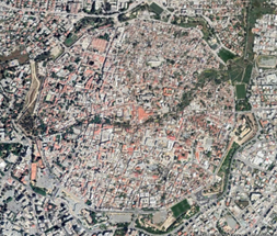
Figure 1. Nicosia Walled City Satellite Image
(Google Earth - 2020)
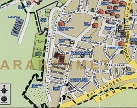
Figure 2. Arabahmet District Plan
(Map Office of TRNC - 2014)
Victoria street
At present re-named as Şehit Salahi Şevket Street, but still known as Victoria Street, which was a very active arterial road during the British period of Cyprus, is in the walled city, in Arabahmet Neighborhood, stretching in a north-south direction between Müftü Ziyai Efendi Street in the north and Baf Street in the south. Its south end being on the borderline between the Turkish and Greek parts of Nicosia, the street houses structures from various historical periods, most of which are houses, and has an important place in the historical city texture of Nicosia. On its north end stands Arabahmet Mosque while the Holy Cross Catholic Church is on the south end of the street, right on the border between the Turkish and Greek parts of Nicosia (Figures 3, 4). The historical formation and development of Victoria Street is described below in the chronological order:
 Street Plan.png)
Figure 3. Victoria (Şht. Salahi Şevket) Street Plan TRNC - 2014)
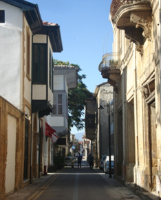
Figure 4. Victoria (Şht. Salahi Şevket) Street (Map Office of (Author - 2020)
Byzantine Period (395 - 1191)
Although there are no works in the historical texture of the walled city of Nicosia from this period, according to some sources (Bağışkan, 2013) there was a religious building in the place of the Armenian Church (Notre Dame de Tyre) in Victoria Street, from the VIII. Century. During this period a church was built in the spot where the present day Armenian Church is in 1116, by the King of Jerusalem, Baldwin de Buillon (Bağışkan, 2013). Therefore, it can be seen that the first formation of the historical texture of Victoria Street began over a thousand years ago, with a church built here during the Byzantine Period of Cyprus.
Lusignan Period (1192 - 1489)
The church built in the same place as the present day Armenian Church, during the Byzantine period, in 1116, was turned into a Carthusian Nunnery a few years after the start of the Lusignan period, and was used by the nuns of the Benedictine sect coming to Cyprus about a hundred years later. This church was completely ruined by an earthquake in 1303 and the present day Gothic style church (Notre Dame de Tyre) was built in its place by King Henry II between 1308 and 1310 (Bağışkan, 2013). According to this source the first building of the historical texture of Victoria Street reaching the present day, the Armenian Church, was built during the Lusignan period (Altan, 2006), (Figure 5, 6).
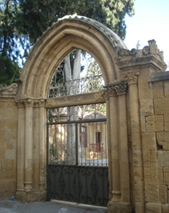
Figure 5. Gate of Armenian Church & Monastery
(Author - 2020)
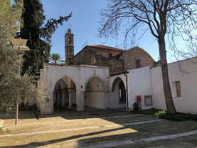
Figure 6. Armenian Church & Monastery
(Author - 2020)
Venetian Period (1489 - 1570)
There were no formation or development in the texture of Victoria Street during the Venetian period as priority was given to defense against attacks from abroad.
Ottoman Period (1571 - 1878)
During the first year of the period, the Armenian Church was taken away from the Armenians and was functioned as a salt storage. When the Armenians informed the Ottoman Sultan Selim II of the situation and they complained about it, the church was returned to the Armenians by an imperial decree. A babtismal room was built in 1788, and the belfry was added to the church in 1860 (Bağışkan, 2013). Information is also obtained (Bağışkan, 2018) that a church was built on the west side of the south end of the present day street in 1642, where the present day Catholic Church stands.
One of the works of the Ottoman period, which contributed extensively to the development of the historical texture of walled city of Nicosia, is Arabahmet Pasha Mosque, still serving with its authentic function. The mosque takes place in the corner parcel on the west side of the north end of Victoria Street opening into Müftü Ziyai Efendi Street. According to some sources the mosque was built by the Governor of Cyprus Arap Ahmet Pasha between 1584 and 1587 (Bağışkan, 2005; Yorulmaz, 2009). Other sources claim that it was built during the beginning of the XVII. Century (Anonymous, 1982; Aslanapa, 1975; Turkan, 2016; Yıldız, 1994). Built with finely cut stones, the mosque has a square plan and is covered with the dome on an octagonal frame and with half domes on each four corners. Pendentives were used as transition elements to the dome. The narthex of the mosque is in the shape of a porch with a pointed arch, in the northwest of the mosque, stretching in the east-west direction, and covered with three domes. The minaret is in the north-west corner, adjacent to the mosque, built with straight cut stone, and has a single balcony and a metal spire. The yard of the mosque houses a hexagonal fountain and several tombs, some of which belong to administrators of the Ottoman period (Figure 7). Arabahmet Pasha Mosque has contributed to the historical texture of Victoria Street as an important symbol of the Ottoman period, and still survives as an element giving life to the street.
During the final years of the Ottoman period a few houses were built in the street, in the character of the XIX century Traditional Turkish House. These houses, symbolizing the period, with their two floors, a yard, a bay window projecting into the street, their plain façades and wide, wooden, slanted and eaved roofs, also contributed to the formation of the historical street texture (Figure 8).
Arabahmet Pasha Mosque in the north, and the church which was built in the south in the place of the present day Catholic Church, built during this period, established the beginning and end of the street texture.
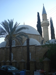
Figure 7. Arabahmet Pasha Mosque
(Author - 2020)
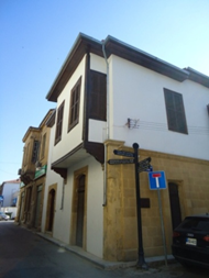
Figure 8. Example of Traditional Turkish House
(Author - 2020)
British Period (1878 - 1960)
The formation and development of the historical texture of Victoria Street continued during this period with new constructions. Initially, three houses dated back to 1891, right after the beginning of this period, were added to the texture. As a continuation of the Traditional Turkish House architecture of the previous period, the Ottoman period, ground floors were generally constructed with cut stones, a local material, and upper floors, with a central hall plan, were built with mud brick. These houses have arched doors, rectangular shaped windows with wooden blinds, and bay windows supported with timber corbels. Their roofs are sloping type, made of timber structure and covered with roof tiles. The houses with dates such as 1893, 1900, 1907, and 1920 on the iron lattice of their doors, with shops on their ground floors, also carry the characteristics of the Traditional Turkish Houses, and give a silhouette to the street with their bay windows and wide timber ceilings with eaves (Cogaloglu & Turkan, 2019), (Figure 9 a, b, c).
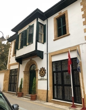
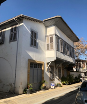
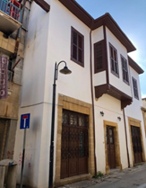
Figure 9. a, b, c. Examples of Traditional Turkish Houses in The Victoria Street (Author - 2020).
Although the housing structures, built with local material of clean-cut stone, especially constructed after 1920, bear the characteristics of the Ottoman period in their plans, they added a different architectural style to the historical street texture with their design of façade, bay windows made of stone, or balconies with iron railings (Figure 10 a, b, c).
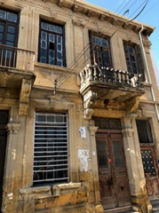
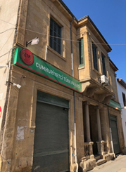
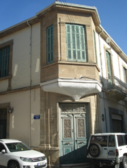
Figure 10. a, b, c. Two Stories Houses Made by Stone in Victoria Street (Author-2020).
The modern architectural current that started with Cypriot architects who studied abroad and returned to the island in 1950s, and with the buildings constructed with the concrete skeleton system, contributed the formation and development of the texture of Victoria Street. The three floor apartment building (Hacı Münür Efendi Apartment), with shops on the ground floor and houses on upper floors, placed on the east corner parcel of the north end of the street was built in early 1950s, and the three floor concrete apartment building (Orhan Şevket Apartment), again ground floor designed as shops and upper floors as houses, placed on the corner parcel in the south, where Victoria Street merges with Kamil Pasha Street in the east, was built in mid 1950s. Apartment buildings gave a new character to the historical texture of Victoria Street, being different from traditional architecture (Figure 11, 12). The Holy Cross Catholic Church in the east of the south end of Victoria Street, at present being beyond the border, in the Greek part of Nicosia, was built during 1900-1902, in place of a church that existed during the Ottoman period. In 1959, a monastery building was added next to the church (Bağışkan, 2018).
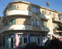
Figure 11. Hacı Münür Efendi Apartment
(Author - 2020)
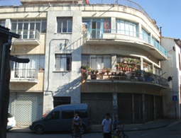
Figure 12. Orhan Şevket Apartment
(Author - 2020)
The British period provided a great contribution to the formation and development of the historical texture of Victoria Street with contemporary housing structures of mostly two floors, and the shops on the ground floors of these buildings made it an important arterial street of walled city of Nicosia with their active commercial functions. Moreover, the Holy Cross Catholic Church of the present day historical texture of the street being built during this period, formed the south border of the street just like Arabahmet Pasha Mosque marks the end of it in the north.
From Republic of Cyprus Period to the Present (1960 - …..)
Victoria Street preserved its importance during the Republic of Cyprus, which was founded in 1960, as an active arterial street of walled city of Nicosia the capital. Shops and houses built with the reinforce concrete and frame structure system in the street during this period took their place in the street texture in contrast to the earlier wall structure system constructions, and formed a contradiction with the historical texture (Figure 13 a, b).
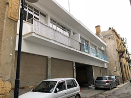
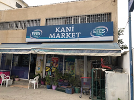
Figure 13. a, b. Frame Structure System Buildings in Victoria Street (Author - 2020)
As a result of political disagreements and armed conflicts which began at the end of the third year of the Republic of Cyprus, Nicosia was divided into two, Turkish and Greek sections, at the beginning of 1964; the south end of Victoria Street became a border line and was closed to traffic at that end. The Armenian population of the street, which contributed greatly to the street becoming an important active arterial road of Nicosia, left Victoria Street and settled in the Greek part of the city. Turkish Cypriots that were forced to leave their homes and take refuge in the Turkish part of Nicosia were settled in the houses and shops abandoned by the Armenians, resulting in a change of the demographic state of the street.
There had been no change or development in the historical texture of Victoria Street until the 1980s, and wear and damage was seen in the texture due to neglect because of the economical inadequacy of the people residing there. During the first years of the Turkish Republic of Northern Cyprus, founded in north Cyprus in 1983, two floor housing constructions were built on the north corner parcel where Derviş Pasha Street stretching westward vertically and forms a conjunction with Victoria street, addressed at both streets. The facades of these houses, one facing Derviş Pasha Street and one facing Victoria Street, are designed in harmony with the traditional houses in the street, with their bay windows, oblong shaped windows with timber blinds, and white washed (Figure 14).
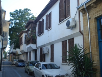
Figure 14. Two Floor Housing Constructions in Victoria Street (Author - 2020)
Again, during this period, Bohcalian Mansion, an important sample of Traditional Turkish Houses of Nicosia in Victoria Street, and other houses with Turkish House characteristics were renovated by the Nicosia Turkish Municipality with the sponsorship of the United Nations and became functional again. At present, Bohcalian Mansion is used as a restaurant and other buildings as houses. The Armenian Church and Monastery were renovated between 2009 and 2012, funded by USAID, and in 2015 this renovation was given the Europa Nostra prize (Anonymous, 2015). In recent years some houses in the street have been renovated by individuals and institutions sensitive towards preservation of cultural heritage, and have become functional. The south end of the street being on the border made Victoria Street a one-way road, thus owners of shops and houses without contemporary accommodation rented them to families of lower income and cultural level. This resulted in the historical street texture, which is a cultural mosaic, being damaged due to the unconsciousness and inadequacy of the users.
Conclusions
Walled city, the city center of Nicosia where the historical city texture takes place, is a mosaic of cultures with all the architectural heritages of various cultures in the history of Cyprus, and its historical neighborhoods still survive as important parts of texture. Being a special protected area at present, Arabahmet Neighborhood has always preserved its importance in the history of Nicosia with the rich cultural properties it incorporates. The most important and active arterial street among the historical street textures of the neighborhood is Victoria Street (Şehit Salahi Şevket Street), as it is known with its British period name. The formation of the historical texture of the street, where mostly Armenians of Nicosia used to live, dates back to the Byzantine period of Cyprus (395-1191). Starting with a religious building constructed in the space where the street is now, the formation of the street texture gained ground during the Lusignan period (1192-1489) with the construction of the Gothic style Notre Dame de Tyre Church built in the place of the former building. There had been no development or change in the formation of texture during the Venetian period (1489-1570). The classic Ottoman style Arabahmet Pasha Mosque, built at the northern end of this place, and the church built at the south end during the Ottoman period (1571-1878), formed the symbolic borders of the present day street texture. Also, a few houses in the Traditional Turkish House style located here during the Ottoman period, in the XIX. Century, contributed to the formation and development of the street texture.
Development of the historical texture of Victoria Street took place during the British period (1878-1960). In the beginning, houses were built in the Traditional Turkish House characteristics under the influence of the Ottoman period, displaying plain facades with windows having timber blinds, bay windows, and slanted roofs with wide wooden eaves; but in the 1920s two-floor buildings were constructed using cut stone materials, having non plastered facades, bay windows or balconies, and shops on the ground floors and houses on the upper floors. These constructions were added to the texture and the street was shaped. Beginning with the 1950s, three-floor concrete apartments with shops on the ground floors as previously, and houses on the top floors were added to the texture, and thus the development continued. The street texture was completed at the south end with the construction of the Catholic Church in place of the earlier church in the first years of the XX. Century and with the addition of a monastery in 1959, the final year of the British period. Development of the street texture was completed to a great extend during the British period with shops and houses built in various architectural styles. Moreover, religious buildings of different beliefs, and people of different ethnic backgrounds residing here, it became a cultural mosaic. With its social, as well as active business life, Victoria Street had turned into an important arterial road of the walled city of Nicosia during the British period.
The one or two-floor shops and houses, constructed using contemporary materials and frame structure system with the beginning of the Republic of Cyprus period (1960) formed a contradiction with the historical texture of the street formed by traditional buildings. As a result of the inter-communal political strife and armed conflicts at the end of 1963, Nicosia was divided as Turkish and Greek parts, and the south end of Victoria Street was on the borderline. With the Armenians deserting the neighborhood, demographic structure of the street underwent a change. As the property owners rented the building in the street to families of low income with lack of environmental and cultural consciousness, the historical texture suffered from insufficient protection and was damaged. Arabahmet Neighborhood was declared as a special protection area under the Nicosia Master Plan at the beginning of the 1980s, and a two-floor concrete building constructed in the street was designed so that its façade was in accordance with the historical texture. In addition, a small number of houses were renovated under United Nations sponsorship as well as by individuals and institutions, thus giving them life again.
At present, the historical texture of Victoria Street is standing the test of time in preserving a highly valuable cultural heritage for the future with its history of more than a thousand years and the Armenian Church and Monastery, Arabahmet Pasha Mosque, Traditional Turkish Houses, British period buildings, and the first multi-floor concrete buildings of the walled city.